

The Best Hikes in Whistler: Trails for Every Level of Adventurer
Whistler isn’t just for skiers and snowboarders—it’s a hiker’s dream, too. With trails that range from gentle lakeside loops to epic alpine climbs, there’s something for every ability and ambition. Whether you're looking for a casual nature walk or a challenging summit, Whistler delivers the views—and the adventure.
Here’s a guide to some of Whistler’s best hikes, organized by difficulty, with links to trail maps and seasonal tips to help you plan.
Easy Trails: Scenic Strolls Close to the Village
Lost Lake Loop
Distance: 5 km loop | Elevation: Minimal
A local favourite for good reason. This accessible trail winds through a forest of evergreens and opens up to peaceful Lost Lake—perfect for a swim or picnic. Just a short walk from Listel Whistler, a Coast Hotel.
Lost Lake Trail Map
Train Wreck Trail
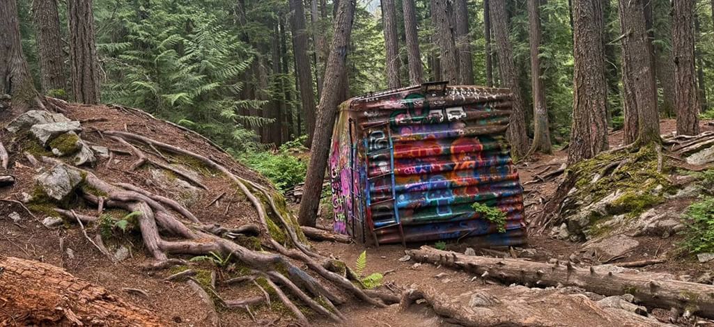
Distance: 2 km round trip | Elevation: 30 m
This easy hike features a suspension bridge over the Cheakamus River and leads to a group of colourfully graffitied train cars hidden in the forest. A unique mix of art, history, and nature.
Train Wreck Trail Map
Moderate Trails: More Distance, More Reward
Brandywine Falls
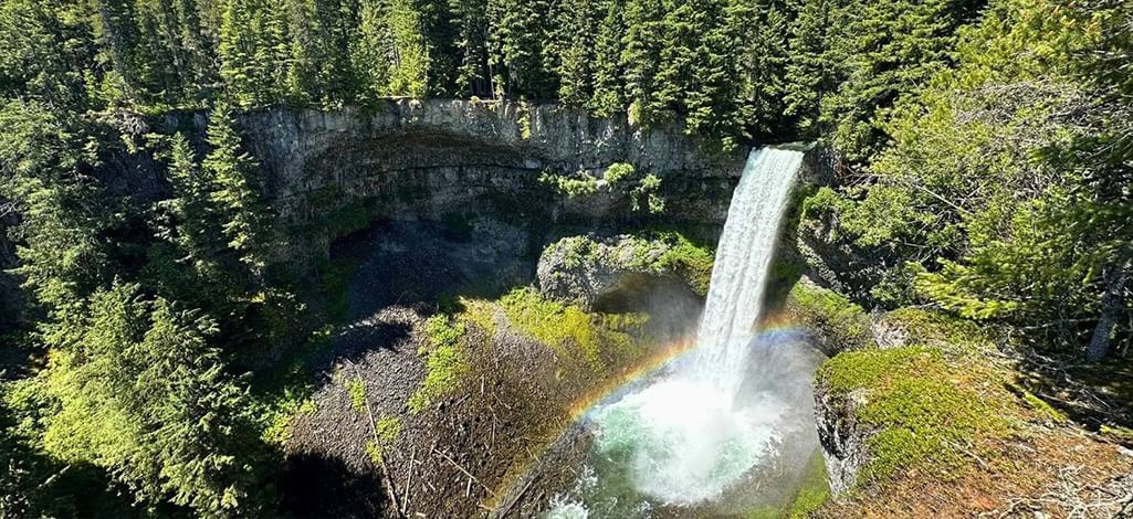
Distance: 1 km (viewpoint) | Elevation: Minimal
A short walk with a big payoff. From the viewpoint, take in a 70-metre waterfall plunging into a deep canyon. It’s an easy drive south of Whistler and a great stop en route to other adventures.
Trails Near Brandywine Falls
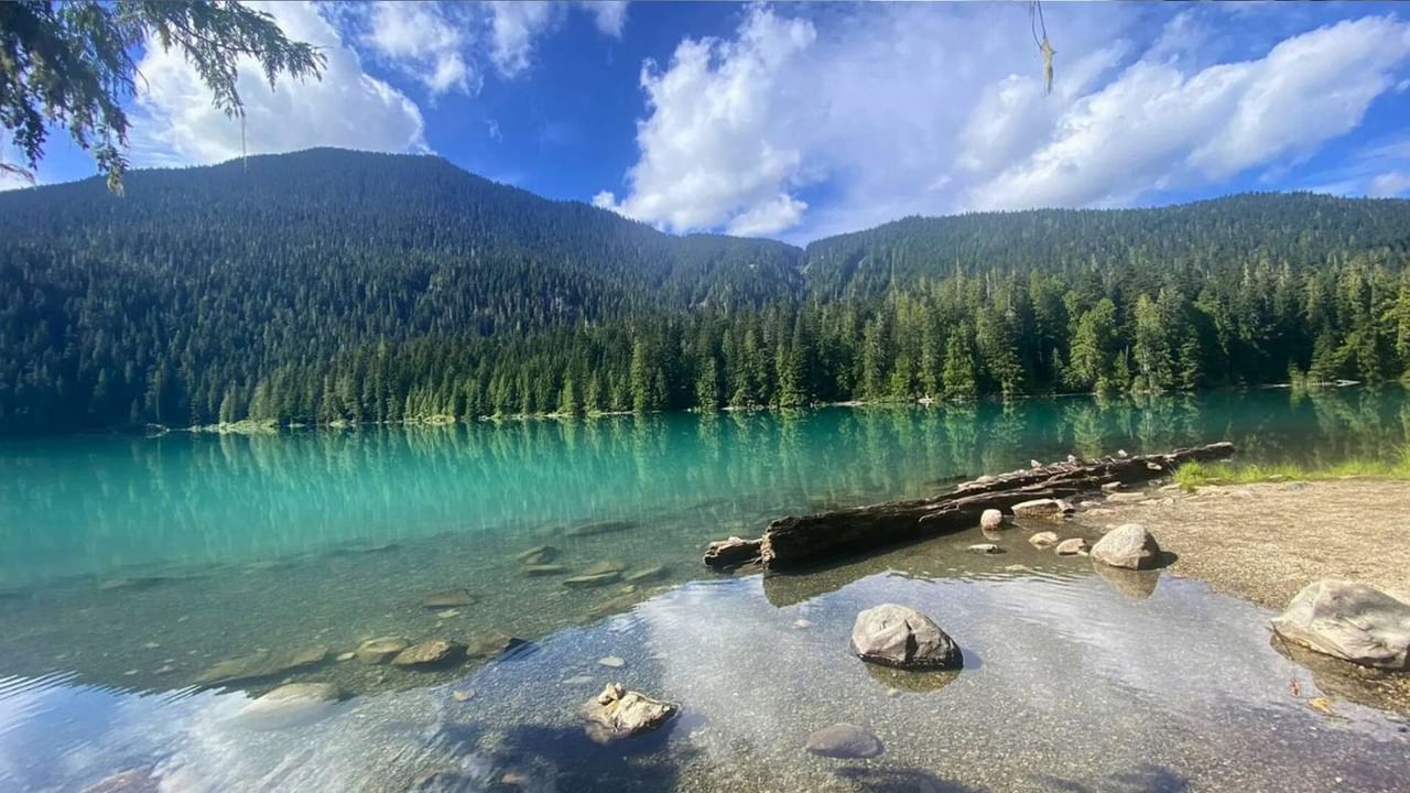
Cheakamus Lake
Distance: 14 km round trip | Elevation: 80 m
This mostly flat trail follows a forested path to the stunning turquoise waters of Cheakamus Lake. Ideal for a full-day outing, with minimal elevation gain but lots of beauty.
Cheakamus Lake Trail Map
Challenging Trails: For the Seasoned Explorer
Blackcomb Ascent Trails
Distance: Up to 6.1 km one way | Elevation: 1,200 m
A series of interconnected trails that climb Blackcomb Mountain—choose your start point based on how much elevation you’re up for. Hike up and reward yourself with a gondola ride back down.
Blackcomb Ascent Trail Map
Panorama Ridge (Garibaldi Provincial Park)
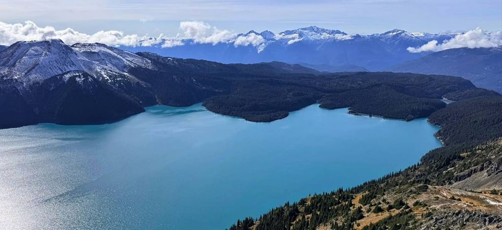
Distance: 30 km round trip | Elevation: 1,500 m
One of the most iconic hikes in British Columbia. It’s long and steep, but the panoramic views over Garibaldi Lake and surrounding peaks are unmatched. Overnight camping is a great way to split the journey.
Panorama Ridge Trail Map
Seasonal Hiking Tips
- Spring (April–June)
Lower elevation trails like Lost Lake and Train Wreck are your best bet—higher alpine routes may still be snowbound. Always check trail conditions before heading out.
- Summer (July–August)
Peak hiking season. Most trails are snow-free, wildflowers are in bloom, and the alpine is wide open. Great time for full-day hikes like Cheakamus Lake and Panorama Ridge.
- Fall (September–October)
Cooler weather and fewer crowds make this a great time to hike. Expect brilliant autumn colours and crisp air—but pack for changeable conditions and shorter daylight hours.
- Winter (November–March)
Many trails transition to snowshoeing routes. Lost Lake’s cross-country and snowshoe trails are popular winter alternatives. Always check avalanche forecasts for backcountry routes.
Whistler Trail Conditions – Tourism Whistler
Your Home Base for Hiking Whistler
Wherever your hiking boots take you, Listel Whistler, a Coast Hotel is the ideal place to rest up afterward. We're steps from Whistler’s trail network and gondolas, and we offer cozy rooms, secure bike storage, and underground parking. After a day outdoors, wind down with a meal at Bearfoot Bistro or a visit to the legendary Ice Room.
Ready to hike Whistler? Your alpine escape starts here.